Puerto Rico residents watching CBS This Morning on Saturday scratched their heads when the news outlet broadcast a map of the caribbean that made the U.S. territory appear to have replaced the sovereign nation of Jamaica. It’s not the first geography fail by a major U.S. network, and we doubt that it will be the last. Less that cogent cartography has plagued print outlets as well, from the Economist (who grossly overstated North Korea’s missile threats) to the New York Times (who prototypoed the nation of Kyrzbekistan). CBS’ Puerto Rico drew lols on Twitter from Puerto Ricans who posted screenshots of the show as it aired live.
The CBS report tracked Hurricane Danny on a map of the caribbean, which it predicted would pass from east to west over the Leeward Islands, an apparently unnamed island (actually Puerto Rico) before diminishing over the Dominican Republic and two other unnamed political entities (Haiti and the Cuba) before threatening the island of “Puerto Rico” (actually Jamaica). In fairness, the online print edition of the CBS report got it right.
“‘This storm has created a lot of expectations,’ said Carlos Anselmi with the National Weather Service in San Juan. ‘But we cannot talk about how much rainfall is expected because the storm is quite small. There's a lot of uncertainty still,’” the website wrote.
From Puerto Rico to São Paulo to the Mexican state of Sonora, expectations of news television accuracy in maps have generated far lower expectations that that storm. And if we’ve noticed any uncertainty, it is whether or not to trust newsrooms with basic geographical facts. So here a throwback to the 3 worst cartography fails we’ve ever caught on television in the hope that readers will brush up on their Latin American geography.
Learn geography with @CBSThisMorning! pic.twitter.com/3SuzJ4iJni
— Eli Pocrita (@EliPocrita) August 24, 2015Asian financial capital, or Latin American one?
CNN’s graphics can be pretty sleek, but they’re not always accurate. A 2013 report on dangerous hornets in Hong Kong labeled the the Chinese financial center city in South America, oddly close to the São Paulo, the banking capital of Brazil.
Oh no, CNN--that's not where Hong Kong is! pic.twitter.com/uCct4WsbOh
— Traci Lee (@traciglee) October 7, 2013South Africa Or South America; Which World Cup?
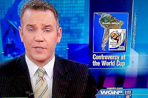
Rio de Janeiro, Brazil, is set to host the World Cup in 2016. But it appeared to be part of a “South Africa” World Cup controversy when that African nation hosted the up in 2010, at least when looking at the graphic used by the American WGN TV station, in which a map of South America was used to represent South Africa. According to The Mirror , South African bloggers complained about the coverage writing sarcastically “It's great to know that America is living up to our expectations,” and “At least they got the hemisphere right.”
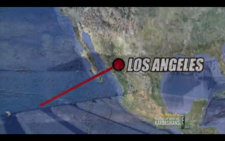
“Eeee!” Everyone In L.A. Is In Mexico
Yes, many Los Angelinos are Norteños, but this E!pic geography fail took the steriotype a bit far, placing Los Angeles somewhere near Sonora, Mexico. This fail was caught by Redditor Jesuishunter.

© 2025 Latin Times. All rights reserved. Do not reproduce without permission.


